Mount Baldy is the highest peak in Southern California at 10,064 feet of elevation. Mount Baldy is a nickname for the mountain; the actual name of the mountain is Mount Antonio. People nicknamed it Mount Baldy because the peak is so high in altitude that no vegetation will grow on the top and someone looked at the mountain and thought it looked like a bald man’s head. Thus, the name Mount Baldy was born. Even though it’s a nickname, the name Mount Baldy is more commonly used and the street to up to the Mountain and the town at the base of the mountain are both called Mount Baldy. Have I used the word Baldy enough?
This hike is rough, but beautiful. There’s A LOT of elevation gain in a fairly short time period and then going back down isn’t any easier. You can do the hike in a loop, which is always nice so then you get to see different things on the way up and the way down. We took Devil’s Backbone trail up to the summit and then Baldybowl trail on the way down.
To get to the hike, you have to drive up a windy road through a tiny town that reminds of the towns near Yosemite that are sort of nestled in the crook of a mountain. The road has some sharp turns and at some points it curves around at nearly 180 degrees.
The trail starts up a fire road. At first it’s paved and then it turns into a gravel road at the turn off to go up the Devil’s Backbone trail. The trail climbs fairly steadily, but it wasn’t too difficult and we still managed to do about a 20 minute mile. The trail is actually really pretty and there is a view through the mountains towards the ocean the entire time you walk up. We couldn’t actually see the ocean because there was a lot of haze, but I bet without the June Gloom there you would be able to see it in the fall or spring. There are also a lot of beautiful Yucca plants on the trail peppered among the pine trees and manzanitas. Right when you start up the trail about a half mile in there’s a pretty view of a multi-layer waterfall. As you’re walking up the trail in this part there is a ski lift running up the mountain that the switchbacks of the path sort of zig zags under. All I can say is that I really wanted to get on that ski lift a few times.


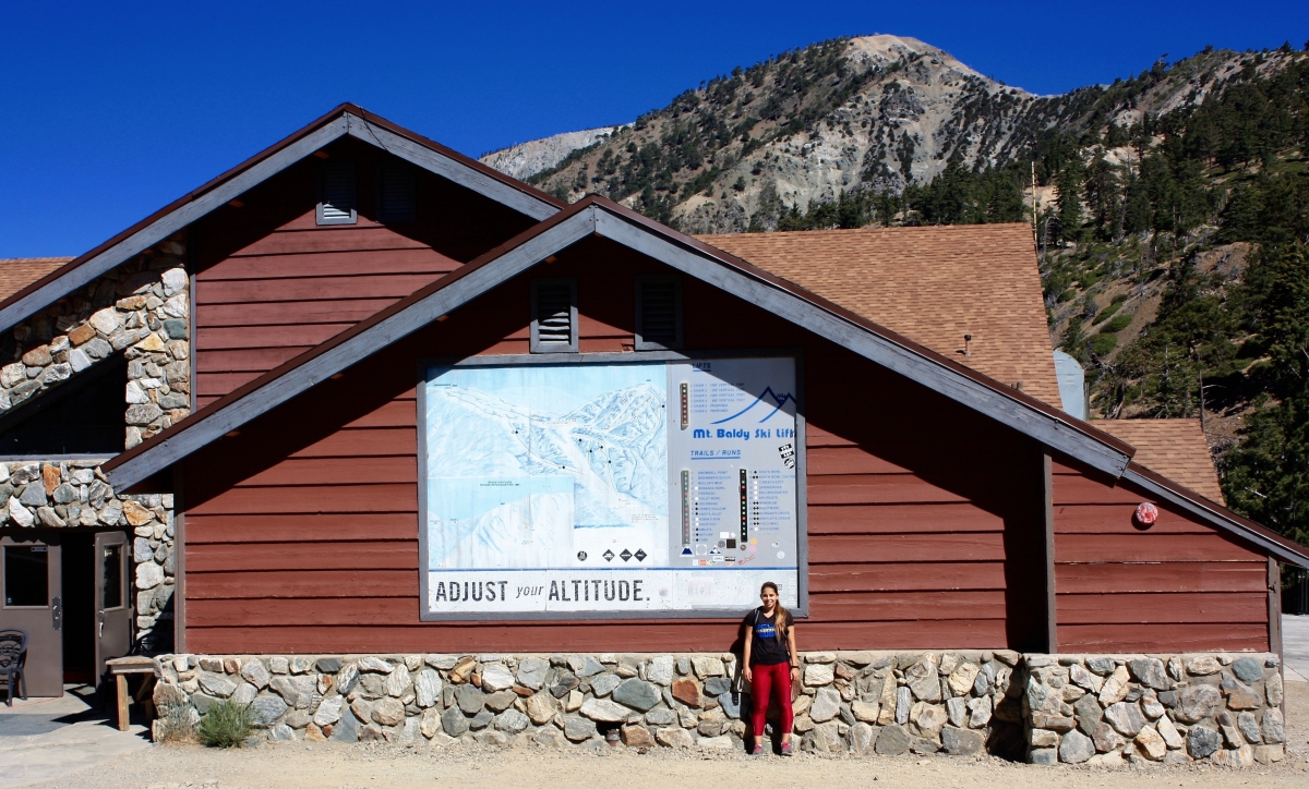
Eventually, the trail literally runs into the ski lodge. At this point we got a little confused because we thought it was strange that a trail just ran into the lodge, but my dad ran inside the lodge and asked one of the workers where the trail was and he told us to take the middle trail that run under the ski lift. My dad and I both took a photo next to the ski lodge because there was a cool sign that said “adjust your altitude” and because it perfectly framed Mount Baldy in the background. It also was definitely very weird to see a bunch of equipment such as snowmobiles and sledding hills without any snow.


I’m going to be honest with you, the next part of this hike is straight up awful. You gain so much freaking elevation in so little distance. The trail from the ski lodge is pretty steep, but it’s also kind of nice because you can finally see over the top of the mountain to the other side. It’s a pretty view because you can see the mountains on the other side and the squares of agricultural fields cut out in the distance beyond the mountains, almost like you’re looking at it from an airplane.


The next part of the hike is called Devil’s Backbone, and it’s aptly named. There’s a steep drop off on one or both sides of the trail at this part. It kinda does look like you’re walking along the backbone of the devil. It’s a little freaky at times because the path gets really narrow, but as with the rest of this hike, the views are really pretty. This past winter, there were actually two hikers who fell to their death off of this trail because it was icy and slippery and the trail is incredibly narrow. We just took it slow and were careful and it was kind of a fun trail once you got past the being freaked out part.


This next part is easily the hardest part of the hike. The hiking manual made my dad and I laugh because it said “this part of the trail has deterred many an experienced hiker”. The trail essentially just goes straight up the mountain in a curvy path. It’s unreal. I barely took any photos because I was breathing so hard and just sort of forgot I had a camera around my neck. There were a few large-ish snowpacks that I just didn’t get a good photo of, although you can see it in the left corner of one I took of the trail. I think it took us 40 minutes to do one mile. The elevation gain is also killer and I think my dad and I may have both gotten acute altitude sickness because we had terrible headaches. I essentially felt like I was crawling up the side of this mountain. I’ve done many a hike, including half dome and parts of the High Sierra Loop Trail, and this may have been the most difficulty I’ve ever had on a hike. My feelings about it can be accurately described by a man who made it to the top after us. He walked up the sign that signified you made it to the top, yelled “F*CK” at the top of his lungs, and then collapsed into a heap on top of his backpack. Same bro, same.


The summit of Mount Baldy is, as one would expect, quite bald. It wasn’t that windy the day we went up there, but another hiker whom I met at the top who’s done this hike every year for about 20 years told me it can get quite windy. There are piles of stones at the top that I’m sure are there for hikers to sit in and get out of the wind. My dad and I ate a sandwich and some snacks at the top, and then started on our way down.


We took Baldybowl trail on the way down. Another hiker who passed us said she’ll take this way up and down because it’s shorter, but I would never want to hike up this trail because it’s so dang steep. The downhill was almost as bad as the uphill for us, but that’s mainly because my dad and I both have hiking shoes that are over 6 years old and because we didn’t bring any poles with us. If I went on this hike again, I would definitely bring poles. It’s incredibly steep downhill (steeper than the way we took up) and poles would have kept us from sliding as much as we did and having to grab onto rocks every time there was a large drop. Just to give you an idea, there were parts of this hike that went downhill so quickly that I thought it was a water shoot and I was looking around for the actual trail. I would’ve done anything for a switch back.
Along the trail on the way down there are some interesting sights. We got to cross over a tiny stream and I thought it was very cute. There was also a ski lodge built in the 1930’s along the trail that’s owned by the Sierra Club and painted a vibrant green color. It had some chairs out front that were carved out of trees that were, as my dad would say, “nifty”.


After about 4 and a half miles of this death of a downhill trail where I lost a few toenails, you make it back to the fire road and back past the waterfall. I can’t say that I was sad to end the hike at this point, but I’m glad I did this because it was a challenge, I got to spend some time with my dad, and I got to spend an entire day outside after two weeks of being cooped up inside studying for finals. Nature always makes me happy. 🙂

Thanks for reading! See ya next time folks!
